Back to Meteorite List
At 7th Aug.2010 08h(UT) or after, an intense sonic boom reached around Ise bay and "Tokai" directions.
On the other hand, some tens of persons in a more broad area witnessed a fireball at 08h 01m(UT).
The fireball flight over the blue sky produced the meteorite cloud that persisted for two minutes duration.
Dr.Yamada calculated trajectory from many seismographs recorded of sonic boom waves.
While no photographs were recorded because day time phenomenon.
We calculated the trajectory used by three meteorite cloud photographs.
Large reduction error of images and meteoritic cloud drift by stratosphere wind with convection climb motion resulted large cloud position error.
The trajectory was decided below results involve some km error that was caused by not simultaneously taking three photographs.
The Meteorite might fall on the peak Tochu region or west of Lake Biwa.
Trajectory of lake Biwa fireball.
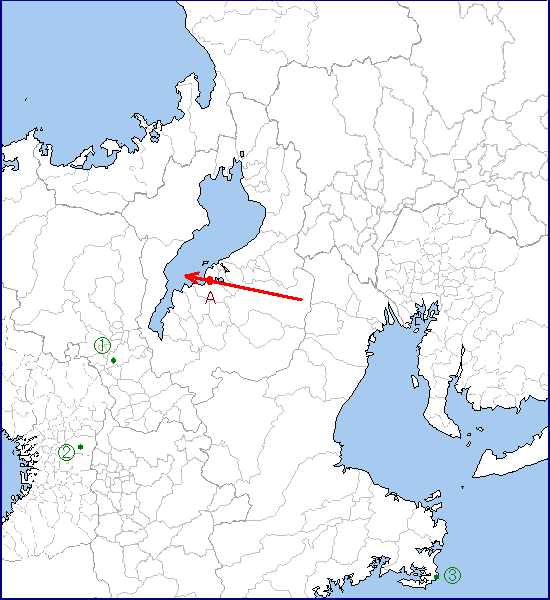
1,2,3: Meteoritic cloud photographed site(Fushimi, Kyoto city, Higashi-Osaka city, Shima city, Mie prefecture)
A: The thickest part of the meteoritic cloud: Omihachiman city, Shiga prefecture 30km altitude.
The trajectory elevation angle is about 55 degrees.
リンク
National Research Institute for Earth Science and Disaster Resilience,(In Japanese)
Sonic boom research by Dr. Masumi Yamada,(In Japanese)
©copyright 2022, Yasuo SHIBA, All Right Reserved